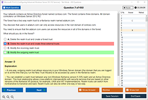
Introduction
In the digital age, the need for location-based services (LBS) has increased significantly. With the proliferation of smart devices such as smartphones, smartwatches, tablets, and even smart home devices, understanding how these devices pinpoint your location has become crucial. From navigation systems that guide you to your destination to location-aware apps that offer personalized recommendations, location information plays an essential role in the functionality of modern technology. But have you ever wondered what exactly is used to provide location information to these smart devices?
This blog will explore the various technologies and methods that smart devices use to determine your geographical location. We’ll delve into the role of GPS, Wi-Fi, cellular networks, Bluetooth, and other sensors that work together to give accurate location data. Whether you’re a tech enthusiast, a developer, or someone curious about how their devices track their location, this article will provide you with a comprehensive understanding.
Global Positioning System (GPS)
One of the most well-known technologies used for providing location information to smart devices is the Global Positioning System (GPS). Developed by the U.S. Department of Defense, GPS relies on a network of satellites orbiting the Earth to triangulate the precise position of a device on the ground. GPS has become the standard method for outdoor navigation and location tracking in smart devices, especially in smartphones and wearables.
How GPS Works:
GPS operates through a system of at least 24 satellites that are constantly orbiting the Earth. These satellites send signals that are received by GPS-enabled devices. By calculating the time it takes for these signals to travel from the satellites to the device, the device can determine its exact position in terms of latitude, longitude, and altitude. This system works best in open areas where the device can communicate directly with the satellites.
Accuracy and Limitations of GPS:
GPS is highly accurate, often providing location data within a few meters. However, its accuracy can decrease in challenging environments, such as urban areas with tall buildings (known as the "urban canyon" effect), dense forests, or indoors. In these cases, other location methods may need to be used in conjunction with GPS.
Wi-Fi Positioning System (WPS)
When GPS signals are weak or unavailable, smart devices can rely on Wi-Fi positioning to determine their location. Wi-Fi Positioning System (WPS) uses the known locations of Wi-Fi access points to estimate the position of a device. This method works by measuring the signal strength of nearby Wi-Fi networks and using this data to calculate the device's location.
How Wi-Fi Positioning Works:
Wi-Fi positioning involves the device scanning for nearby Wi-Fi networks. Once the device identifies these networks, it compares the signal strength and matches it to a database of known Wi-Fi access points. The location of the device is then estimated based on the known positions of these access points. This method can be particularly useful in indoor environments where GPS signals are weak or blocked.
Advantages of Wi-Fi Positioning:
-
Works well in indoor environments.
-
Provides relatively accurate location data within a small area, often within a few meters.
-
Often used in conjunction with GPS for better location accuracy.
Cellular Network Positioning
Cellular networks can also be used to determine the location of a smart device. This method, known as cellular triangulation, works by using the signals from nearby cell towers to estimate the device's position.
How Cellular Positioning Works:
Cellular positioning involves the device connecting to the closest cell towers within the network. By triangulating the signals from multiple towers, the device can estimate its location. While cellular positioning is less accurate than GPS, it can be used in areas where GPS signals are unavailable, such as in urban areas with tall buildings or underground locations.
Limitations of Cellular Positioning:
-
Less accurate than GPS or Wi-Fi positioning.
-
Can only provide approximate location data, typically within a few hundred meters to a few kilometers.
Bluetooth Low Energy (BLE) and Beacons
Another technology that is increasingly being used to provide location information to smart devices is Bluetooth Low Energy (BLE), especially in indoor settings. BLE technology is often used in conjunction with small devices called beacons that transmit signals to nearby devices.
How BLE and Beacons Work:
BLE-based location tracking works by using Bluetooth-enabled beacons placed in various locations, such as shopping malls, airports, or museums. These beacons constantly emit signals that can be detected by nearby smartphones or smartwatches. By measuring the signal strength and proximity to multiple beacons, the device can accurately estimate its location within the facility.
Benefits of BLE and Beacons:
-
Highly accurate for indoor navigation.
-
Used in retail, museums, airports, and other venues to offer location-based services.
-
Low power consumption, making it suitable for battery-powered devices.
Inertial Sensors (Accelerometer, Gyroscope, Magnetometer)
Inertial sensors, such as accelerometers, gyroscopes, and magnetometers, are often used in conjunction with GPS, Wi-Fi, and other location technologies to improve location accuracy. These sensors help devices detect movement, orientation, and changes in position.
How Inertial Sensors Work:
-
Accelerometer: Measures the acceleration of the device along three axes, helping to detect movement and changes in speed.
-
Gyroscope: Measures the rotation and angular velocity of the device, helping to determine its orientation.
-
Magnetometer: Measures the magnetic field around the device, providing information about its direction (like a digital compass).
These sensors help fill in the gaps when GPS signals are weak or unavailable, such as when you're indoors or in a moving vehicle. They can also enhance the precision of location tracking by providing real-time data on the device's movement.
Hybrid Positioning Systems
Modern smart devices often combine multiple location technologies to provide the most accurate location information. This approach is known as hybrid positioning.
How Hybrid Positioning Works:
A hybrid positioning system may use a combination of GPS, Wi-Fi, cellular network data, Bluetooth, and inertial sensors to determine a device's location. For example, a device may rely on GPS for outdoor navigation, but switch to Wi-Fi or cellular positioning when indoors. In some cases, the device can also use inertial sensors to track movement when GPS signals are unavailable, such as during a subway ride or while moving through a building.
Hybrid positioning systems are particularly beneficial in areas where one method of location tracking may not provide accurate results. They ensure that smart devices can continue to provide location information even in challenging environments.
Conclusion
Smart devices have become an essential part of our daily lives, and location-based services are at the heart of many of these devices' functionalities. Whether it’s using GPS for navigation, Wi-Fi for indoor positioning, cellular networks for approximate location tracking, or Bluetooth beacons for precise indoor navigation, there are multiple technologies at play to ensure that your smart device knows where it is.
In the future, as technologies continue to advance, we can expect even more accurate and efficient location tracking methods to emerge. Understanding how location information is gathered and processed helps users make informed decisions about privacy and security while using their devices. By combining various location-tracking methods, smart devices can continue to provide us with better, more personalized services, making our lives more connected and convenient.
Free Sample Questions
Q1: What is the primary technology used by smart devices for outdoor location tracking?
A) Wi-Fi Positioning
B) GPS
C) Bluetooth
D) Cellular Networks
Answer: B) GPS
Q2: Which of the following technologies is best suited for indoor location tracking?
A) GPS
B) Cellular Networks
C) Bluetooth Beacons
D) Wi-Fi
Answer: C) Bluetooth Beacons
Q3: How does hybrid positioning improve location accuracy in smart devices?
A) By relying solely on GPS
B) By combining GPS, Wi-Fi, Bluetooth, and cellular networks
C) By using a single method for location tracking
D) By reducing the number of sensors used
Answer: B) By combining GPS, Wi-Fi, Bluetooth, and cellular networks
Q4: What role do inertial sensors (accelerometer, gyroscope, magnetometer) play in location tracking?
A) They replace GPS completely.
B) They help improve location accuracy by detecting movement and orientation.
C) They only work when GPS signals are unavailable.
D) They do not contribute to location tracking.
Answer: B) They help improve location accuracy by detecting movement and orientation.